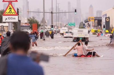
Kherson: The extent of the destruction of a sizable, inundated area of southern Ukraine is vividly illustrated by before-and-after pictures of the region downstream from a dam that collapsed on Tuesday.
Farm fields appear green, crossed by calm farm roads and streets, and dotted with trees before the Kakhovka dam on the Dnieper River broke. After that, only treetops and metal roofs can be seen above the murky water. Homes and greenhouses are nearly completely submerged.
The satellite images from before the collapse were captured in May and early June. Photos of the same region taken following the dam collapse clearly demonstrate how much of it has turned into uninhabitable. Most of the area visible in the images is covered in brown water that reaches heights of people.
Also Read: Brazilian singer Astrud Gilberto dies at 83
The comparison of the disaster's before-and-after satellite images with exclusive drone footage of the Ukrainian dam and its Russian-occupied neighbouring villages shows the dramatic changes that occurred.
Also Read: PM Modi to address Indian Diasporas in Washington on June 23
Since last October, Ukraine has issued warnings that Russian forces had mined the hydroelectric dam and are to blame for setting off an explosion that turned the areas downstream into a soggy wasteland.
Also Read: New York City the worst air quality in the world
Russia claimed that Ukraine fired a missile at the dam. Although the AP video clearly demonstrates the extent of the damage to the area, it only provided a partial view of the dam, making it difficult to categorically rule out any possibility.
According to experts, the building was in poor condition, which may have contributed to its collapse.