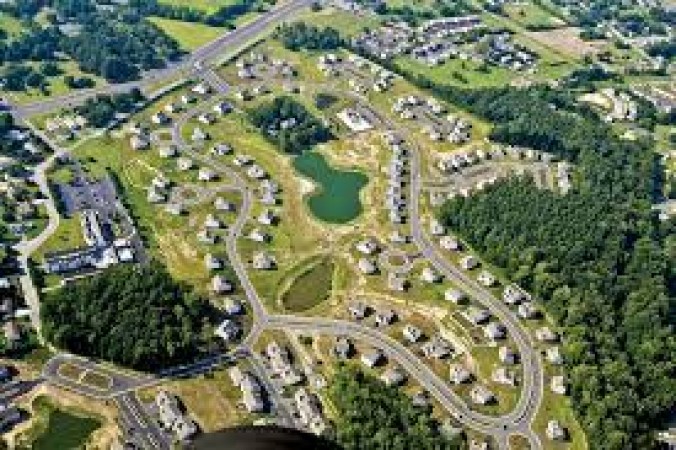
Aerial photography has revolutionized the way we see and understand our world. By capturing images from above, this unique form of photography offers a fresh perspective, unveiling breathtaking landscapes, revealing patterns, and providing valuable insights into various fields. In this article, we will delve into the art and applications of aerial photography, exploring its history, techniques, and impact on industries such as mapping, environmental monitoring, tourism, and filmmaking.
The History of Aerial Photography: The concept of capturing images from the air dates back to the mid-19th century, when the French photographer Gaspard-Félix Tournachon, known as Nadar, took the first documented aerial photograph in 1858. Since then, aerial photography has evolved significantly, progressing from manned balloon flights to the development of specialized aerial platforms like kites, pigeons, and eventually aircraft and drones. Technological advancements in cameras, lenses, and image stabilization have further enhanced the quality and versatility of aerial imagery.
Techniques and Equipment: Aerial photographers employ various techniques and equipment to capture stunning images from above. Traditional aerial photography involves using fixed-wing aircraft or helicopters equipped with high-resolution cameras. These platforms allow photographers to cover vast areas and capture detailed images with precision. However, the use of drones has democratized aerial photography, providing an affordable and accessible alternative. Drones equipped with cameras offer flexibility, maneuverability, and the ability to reach areas that were previously inaccessible, such as densely populated cities or remote natural landscapes.
Applications of Aerial Photography: 3.1 Mapping and Surveying: Aerial photography plays a vital role in cartography, surveying, and mapping. High-resolution aerial images are used to create accurate topographic maps, monitor land use changes, and aid in urban planning. These images provide valuable data for infrastructure development, disaster management, and environmental conservation efforts.
3.2 Environmental Monitoring: Aerial photography is instrumental in assessing and monitoring environmental conditions. It helps scientists and researchers study ecosystems, track changes in vegetation cover, detect deforestation, and monitor the impact of natural disasters. Aerial surveys also assist in wildlife conservation by tracking animal populations, migration patterns, and habitat changes.
3.3 Tourism and Marketing: Aerial photography has transformed the tourism industry by offering captivating images of destinations, landmarks, and natural wonders. These images entice travelers, allowing them to visualize their potential experiences and make informed decisions about their trips. Additionally, aerial photographs are extensively used in marketing campaigns by resorts, travel agencies, and hospitality businesses to showcase their offerings and attract visitors.
3.4 Filmmaking and Cinematography: In the world of filmmaking, aerial photography has revolutionized the way stories are told on the big screen. Aerial shots provide a cinematic perspective, capturing sweeping vistas, dynamic action sequences, and awe-inspiring aerial views. Filmmakers use aerial footage to enhance storytelling, evoke emotions, and create immersive visual experiences for the audience.
Ethical and Legal Considerations: While aerial photography offers remarkable opportunities, it also raises ethical and legal considerations. Privacy concerns arise when capturing images from above, and regulations regarding drone usage and airspace restrictions vary across countries. Striking a balance between capturing stunning visuals and respecting privacy rights is crucial, requiring responsible and ethical practices from aerial photographers.
Conclusion: Aerial photography has revolutionized the way we perceive the world, offering a unique perspective that was previously inaccessible. From its humble beginnings to the modern era of drones, aerial photography has become an essential tool in various industries, including mapping, environmental monitoring, tourism, and filmmaking. As technology continues to advance, the art of aerial photography will evolve, enabling us to capture even more stunning images and gain new insights into our planet. Embracing the potential of aerial photography while addressing ethical and legal considerations is essential for unlocking its full potential and ensuring a responsible and sustainable future for this remarkable art form.
Elevate Your Professional Image with Business Dress Style: Mastering the Art of Dressing for Success
IEA Lowers Oil Demand Forecast as Economic Headwinds Mount
World Hunger Still Rising, Far Off Track to Be Eradicated by 2030, UN Warns