Weather prediction plays a crucial role in our daily lives. Being able to identify different types of clouds can provide valuable insights into upcoming weather patterns. Clouds are indicators of atmospheric conditions, and by understanding their characteristics, we can make more informed predictions about changes in the weather. In this article, we will explore the various types of clouds and how to recognize them, empowering you to become your own weather forecaster.
The Three Main Cloud Types
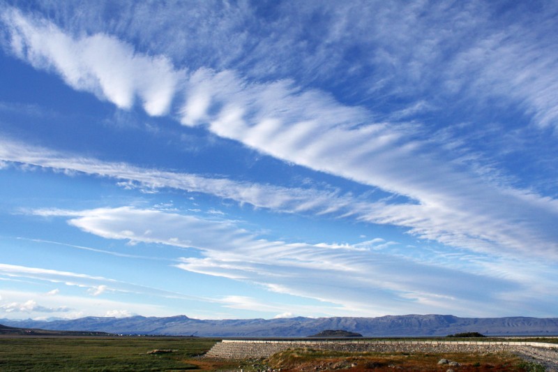
Cirrus Clouds: The High Flyers
Cirrus clouds are wispy, high-altitude clouds that resemble delicate feathers or horse tails. They are usually composed of ice crystals and are often seen at heights above 20,000 feet. Cirrus clouds are indicators of fair weather, but their presence can also precede the arrival of a warm front. Their thin and feathery appearance is caused by the strong winds at high altitudes, which stretch the clouds into their characteristic shapes.
Cumulus Clouds: The Puffy and White
Cumulus clouds are the classic fluffy clouds that dot the sky on bright, sunny days. They are typically low to middle-level clouds with a distinct cauliflower shape. Cumulus clouds form when warm, moist air rises and cools, causing water vapor to condense. These clouds indicate fair weather, but if they grow larger and start to develop vertically, they can evolve into cumulonimbus clouds, potentially bringing thunderstorms.
Stratus Clouds: The Blanket of the Sky
Stratus clouds are low-altitude clouds that form in uniform layers, covering the sky like a gray blanket. They often bring overcast conditions and light precipitation, such as drizzle or light snow. Stratus clouds are also known for creating fog when they touch the ground. Their presence can indicate stable, yet gloomy, weather patterns.
Cloud Variants and Their Indications
Cirrostratus Clouds: The Halo Makers
Cirrostratus clouds are thin, high-altitude clouds that create a halo effect around the sun or moon. These clouds often precede the arrival of a warm front, signaling potential changes in the weather. When cirrostratus clouds thicken and lower, they can evolve into cirrus or cirrostratus clouds, indicating possible rain within the next 24 hours.
Altocumulus Clouds: The Checkerboard Sky
Altocumulus clouds are mid-level clouds that appear as white or gray patches in the sky, often arranged in a checkerboard pattern. They are composed of water droplets and are generally harmless. However, if they increase in size and thickness, they can indicate the approach of a cold front, which may bring precipitation.
Nimbostratus Clouds: The Rain Bringers
Nimbostratus clouds are dark, thick clouds that cover the sky and bring steady, continuous precipitation. They are typically mid-level clouds that can extend to low altitudes. When nimbostratus clouds are present, it is likely that rain or snow will occur for an extended period.
Cumulonimbus Clouds: The Thunderstorm Producers
Cumulonimbus clouds are towering and massive clouds that span low to high altitudes. These clouds are associated with thunderstorms, heavy rainfall, lightning, and strong winds. They can even produce hail and tornadoes under severe conditions. If you spot cumulonimbus clouds on the horizon, be prepared for potentially hazardous weather.
Identifying Clouds Based on Their Shape
Clouds come in various shapes, and understanding these shapes can aid in their identification and weather prediction.
Wispy Clouds: Cirrus and Cirrostratus
Wispy clouds, such as cirrus and cirrostratus clouds, have delicate and thin appearances. Cirrus clouds form high in the atmosphere and are composed of ice crystals, while cirrostratus clouds are more widespread and can create a halo effect around celestial bodies.
Cotton Ball Clouds: Cumulus and Altocumulus
Cumulus and altocumulus clouds have puffy and cotton ball-like appearances. Cumulus clouds are typically seen on fair weather days, while altocumulus clouds may indicate the approach of a weather front.
Layered Clouds: Stratus and Nimbostratus
Stratus clouds form in uniform layers and cover the sky with a grayish blanket. Nimbostratus clouds are similar but bring continuous precipitation.
Towering Clouds: Cumulonimbus
Cumulonimbus clouds are massive and tower into the sky. They are associated with thunderstorms and can bring intense rainfall and severe weather.
By learning to identify different types of clouds, you can become more adept at weather prediction. Clouds are nature's signposts, offering valuable insights into upcoming weather changes. Next time you look up at the sky, take a moment to observe the clouds and use your newfound knowledge to make predictions about the weather. Being a cloud watcher can be a rewarding and enlightening experience, connecting you to the dynamic forces of the atmosphere.
Birthday Special - Wishing the Man of Melodious Voice, Sonu Nigam!