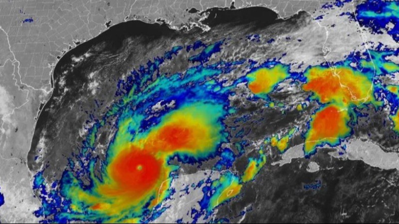
Hurricane Milton, a monstrous Category 5 storm, has intensified and is projected to become one of the most devastating hurricanes to hit Florida in over a century. Residents in the storm's path have been urged to evacuate immediately as the state braces for its landfall.
Evacuation Warnings Issued
Florida Governor Ron DeSantis and local officials have called on residents to complete preparations and leave if they're in the hurricane's path. The National Hurricane Center (NHC) has warned that Hurricane Milton has the potential to be one of the most destructive hurricanes to ever impact west-central Florida. The storm's wind field is expected to double in size before it makes landfall.
Timing and Areas at Risk
Milton is forecast to make landfall late Wednesday or early Thursday, with wind speeds of 165 mph (270 kph). Areas from Bonita Beach to Chassahowitzka are expected to experience storm surges of over 5 feet, while Pinellas County, Sarasota, and Tampa Bay could see inundation between 10 to 15 feet above ground level. State and local governments have declared emergencies, and evacuations are in progress across multiple counties.
Power Outages and Preparations
Power companies have deployed workers from across the country to prepare for what could be widespread and extended power outages. In Pinellas County, about half a million people have been ordered to evacuate, with St. Petersburg expected to experience winds exceeding 100 mph, higher than the damage caused by Hurricane Helene just two weeks ago.
Florida Still Recovering from Hurricane Helene
Hurricane Helene, which hit the Big Bend region as a Category 4 storm two weeks ago, left devastating flooding and destruction across western Florida. With 230 fatalities and thousands of homes damaged, residents are still recovering when the much stronger Hurricane Milton is set to make its approach.
Impact on Mexico and Predictions for Milton
As the storm passed offshore from Mexico's Yucatan Peninsula, minor damage was reported, including downed power lines and trees. No casualties were reported. Hurricane Milton is now the second-strongest hurricane ever recorded in the Gulf of Mexico, only behind Hurricane Rita in 2005. Experts predict that while Milton may weaken slightly before landfall, it will still be a major hurricane when it hits Florida.
Climate Change Concerns
Scientists have linked the intensification of Hurricane Milton to human-caused climate change, which has contributed to the increased severity of hurricanes. Similar effects were observed with Hurricane Helene, where warmer air and moisture led to higher rainfall and stronger winds. This phenomenon is expected to continue as fossil fuel use persists, leading to more destructive storms and inland flooding.
Federal Response
President Joe Biden has declared a state of emergency in Florida and has authorized FEMA to provide disaster relief. The federal government, in coordination with state and local authorities, is preparing to respond to the aftermath of the hurricane and support affected communities.
Unusual "Pinhole Eye" Intensifies the Storm
Experts have attributed Milton's rapid intensification to its unusually small "pinhole eye," measuring just 3 miles in diameter. This compact structure allows the storm's winds to maintain more kinetic energy, driving up its strength. With air pressure at 897 millibars, Hurricane Milton is now one of the most intense storms ever recorded in the Atlantic basin.