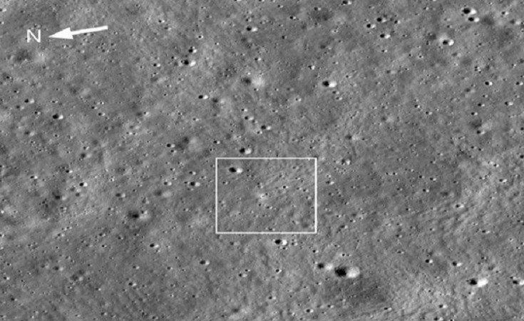
NEW DELHHI: NASA's Lunar Reconnaissance Orbiter (LRO) has recently captured an image of the Chandrayaan-3 landing site, situated approximately 600 kilometers from the Moon's South Pole. The LRO, operated by the American space agency NASA, is currently orbiting near the Moon's south pole after successfully executing a soft landing on August 23.
The image, taken by a camera mounted on the NASA orbiter, offers an oblique view of the Vikram lander, four days after it touched down on the lunar surface. Launched on June 18, 2009, the NASA orbiter has been instrumental in gathering a wealth of data, contributing significantly to our understanding of the Moon.
NASA explained that the bright halo surrounding the vehicle is the result of the rocket plume interacting with the fine-grained lunar regolith (soil). This fascinating discovery was accompanied by a statement from NASA, which included the captured image.
On August 23, India celebrated a remarkable achievement as the Chandrayaan-3 lander module successfully landed on the Moon's South Pole, marking India as the first country to achieve this historic feat. This triumph brought an end to the disappointment stemming from the Chandrayaan-2's crash landing four years earlier. India now joins the exclusive club of countries, including the United States, China, and Russia, that have successfully landed on the lunar surface.
Following their landing, the Vikram lander and Pragyan rover embarked on various tasks on the lunar surface, such as detecting the presence of sulphur and other minor elements, recording temperature differentials, and monitoring surrounding movements. Currently, both the Vikram lander and Pragyan rover are in a "sleep mode," with plans for reactivation scheduled for around September 22, 2023.
In a recent development, the Indian Space Research Organization (ISRO) unveiled a three-dimensional 'anaglyph' image of the Chandrayaan-3 Vikram lander, captured from the Moon's South Pole. An anaglyph provides a simplified three-dimensional visualization of an object or terrain, derived from stereo or multi-view images.
Lunar Mission Updates: ISRO Places Vikram Lander in Sleep Mode
Pragyan Rover Captures Natural Lunar Event at Moon's South Pole: ISRO
Why Were Chandrayaan-3's Lander and Rover Named Vikram and Pragyan?