New Delhi: The southwest monsoon current's arrival over the Kerala coast would likely be delayed by another two to three days due to cyclonic storm "Biparjoy," as per a private weather forecaster on Wednesday.
The arrival of the southwest monsoon over Kerala's coast could be delayed by an additional two to three days due to the development of the cyclonic storm, which has already been delayed by six days.
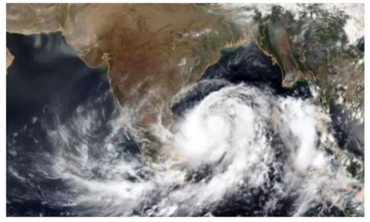
On average, the critical southwest monsoon arrives on the Indian subcontinent by June 1. Kerala's onset was anticipated by the India Meteorological Department (IMD) for 4 June with a four-day error margin last month, while commercial weather forecaster Skymet projected 7 June with a three-day error margin. The first storm to form in the Arabian Sea this year, Cyclone "Biparjoy," has grown into a powerful cyclonic storm.
Within the following 24 hours, Biparjoy, which is pronounced Biporjoy, is forecast to move almost northward and strengthen into a very strong cyclonic storm. According to the most recent IMD advisory, it would then move north-northwestward during the next three days.
The monsoon season, which lasts from June to September, is significant for India, the third-largest economy in Asia since it brings about 70% of the continent's yearly precipitation to that country. Rainfall accounts for 44% of the nation's food production and slightly more than half of its net cultivated land, making it crucial for India's food security.
Apart from power production nationwide, it is essential for the replenishment of reservoirs that are essential for providing drinking water. The agricultural industry employs the most people and makes up around 18% of the economy.
"Once the monsoon arrives over Kerala, it moves slowly across the southern peninsula and central India. By June 12, the monsoon current may form and the monsoon may become more intense across the Central Arabian Sea, according to Palawat. The emergence of cyclonic storm Biparjoy is thought to be the reason why the monsoon is feeble in the South Peninsular and Central parts of the nation. Monsoon is therefore not considered promising.
Farmers in Gujarat, Madhya Pradesh, and Maharashtra may have to sow their vital kharif crops later due to delayed rainfall. While Madhya Pradesh and Gujarat grow rice, soybean, jowar, maize, groundnuts, tur, and urad during the kharif season, Maharashtra grows soybean, tur (arhar), groundnut, maize (corn), and sugarcane. According to the Skymet meteorologist, a delayed and weak monsoon current would likely cause June rain totals to be around 20% of long-period average (LPA).
On Wednesday, winds in the east-central Arabian Sea and surrounding regions of the west-central and southeast Arabian Sea may gust to 115 kmph due to Cyclonic Storm "Biparjoy." The night of June 7 is expected to see an increase, becoming 125–135 kmph with gusts to 155 kmph across the same area. According to IMD, squally winds with gusts up to 60 kmph are predicted to blow over adjacent regions of the west central and south Arabian Sea as well as along and off the north Kerala-Karnataka-Goa beaches.
The meteorological service anticipates rough seas in the adjacent west-central and southeast Arabian Seas and the east-central Arabian Sea. Over the southern Arabian Sea and along and off the northern Kerala-Karnataka-Goa shores, the sea is likely to be rough to very rough. Therefore, it has been urged that fishermen stay out of the Central Arabian Sea until June 13, adjacent parts of the North Arabian Sea from Monday through Tuesday, and adjacent areas of the south Arabian Sea today. Those at sea have been urged by IMD to return to land.

_676d0b9d3bd1a.jpg)


_676d0b9d3bd1a.jpg)