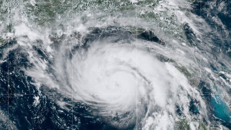
Life-threatening wind could begin along the Louisiana coast as early as Saturday night "and then spread inland to the New Orleans, Houma and Baton Rouge metro areas on Sunday," The National Hurricane Center said in its 6 a.m. update that Hurricane Ida's maximum sustained winds were up to 150 miles per hour with stronger gusts. The storm is about 75 miles from Grand Isle and around 60 miles from the mouth of the Mississippi River. Hurricane Ida showed signs that it had rapidly strengthened in the Gulf of Mexico overnight and the storm could continue to grow stronger before it makes landfall Sunday afternoon, according to the National Weather Service.
A tornado watch has been issued for parts of Louisiana, including New Orleans, Hammond and Bogalusa, as well as parts of Florida, Mississippi and Alabama, according to the National Weather Service in New Orleans. The watch runs through 7 p.m. The Weather Channel said that Grand Isle was already seeing gusts of up to 100 miles per hour. A meteorologist called the intensifying hurricane "very concerning." Sustained winds are up to 150 miles per hour, according to the National Hurricane Center. A Category 5 hurricane has sustained winds of 157 miles per hour.
The 4 a.m. Sunday update from the NWS indicated the storm was about 145 miles southeast of Houma and moving northwest at 16 mph. A slight shift in Hurricane Ida's track to the east on Saturday had forecasters concerned about storm surge and rainfall in areas that can't handle heavy rain, particularly Barataria and Terrebonne bays. If Hurricane Ida's path brought intense rain over New Orleans, forecasters feared it could lead to extremely dangerous flash flooding in the metro area
THIS country warns of terror attacks on Covid vaccine sites